Mt Anne Walk
22 - 24 March 2008
The first section of plain has been burnt, probably from JM-S management burn, and there are plenty of dead sticks to push through and the boggy middle bit . Once through the first forest band it was back to unburnt scrub, although it is getting taller, followed by the ascent through the forest. Here we had several delays in locating the route and areas with Horizontal and other scrub to find a way through, plus a number of branches to clamber under or over.
We were well behind on my original times which brought home to me how much age slows you down; for example the quickest of our crossings of the first part of the plains crossing took 50 minutes as against the old one of 40 minutes. More dramatic was the extra hour to both way between Sandfly Creek and the ridge, partly due to the greater difficulty in finding the track.
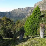
Camp was reached later than anticipated and cloud had enveloped the mountain peaks, but as we started cooking the sky gradually became clearer and clearer and it looked like a cold night was in store. The next morning was glorious with valley mist way below us and we thoroughly enjoyed wandering the shelf to admire the scenery before setting off to climb Mt Anne. Once on the north east face it was easy going on the ledges until just below the summit, where quite a bit of time was spent trying to work out the best way up the final haul. One spot was looked at on several occasions, but I told Mike it looked much harder that way than my memory told me. Eventually we tried a small ledge and scrambled up to the summit, but on return varied this by using a creviced nook with a bush or two at the top and rock hand hold part way down; this proved to easier than first imagined. However I suspect that once it had more hand holds that have possibly fallen out.
Our final day was again pleasant and encouraged more photo taking. On the way back to the car we made a visit to the Anne-A-Kananda cave but the morning sun hadn't penetrated the access way and the rock was slippery, so we didn't risk descending to the underground entrance.
The track to the ridge seems to be getting much less use and it was most noticeable along the ridge and about the area we camped that the impact from walkers had lessened and was now in better condition than on my first visit. The most impact left was the pad running along a wet area immediately below the main ridgeline. On checking an old issue of Australian geographic I read that this track was the one used by cavers to reach their campsite during a 1987 expedition. That party was there for three and half weeks and had close on two dozen members, so one would imagine the track must have a terrible bog by the time they left. After 20 years this bit is still badly damaged, but even here the recovery is noticeable.
 |
| Anne |
Comments
Post a Comment